Table of contents
Valle de la Luna: history and landscape
Origin of the name and history
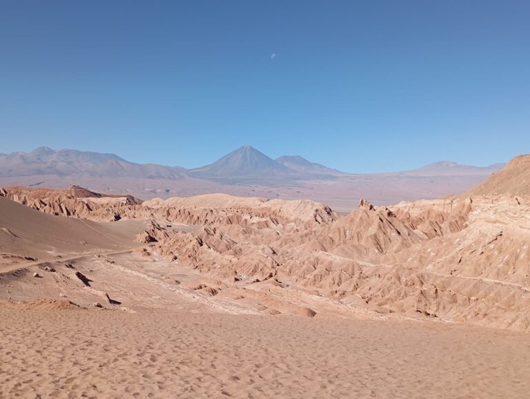
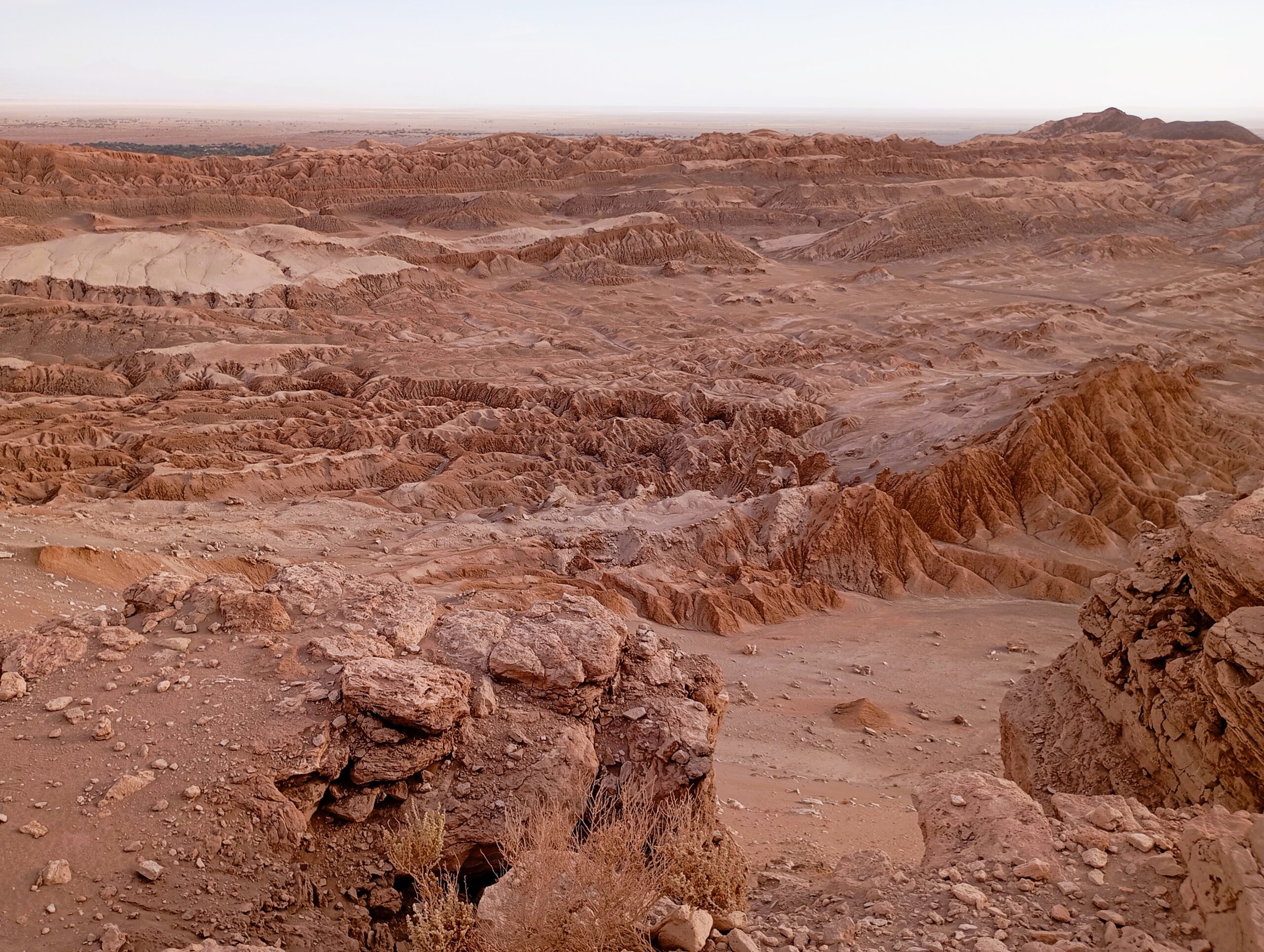
The name Valle de la Luna is no coincidence. Just look at the landscape and it’s easy to see where the comparison comes from: the pale, barren surfaces, irregular formations and almost complete lack of vegetation bring to mind the surface of the Moon, creating an environment that seems almost otherworldly. It is such a distinctive landscape that the area has become one of the most recognizable symbols of San Pedro de Atacama.
The name is traditionally attributed to Belgian Jesuit Gustavo Le Paige, who spent years studying the San Pedro de Atacama area in the 1960s and helped bring attention to its natural and archaeological features.
Before becoming one of the main tourist attractions around San Pedro de Atacama, this area served a very different purpose. The road that now crosses the Valle de la Luna was once part of the old route to Calama, now replaced by the modern road network.
For local communities, the area was also known as Las Salinas, referring to the large amounts of salt found here, which led to the development of small-scale mining activities to extract it. Some traces of these activities can still be seen along the route.
The Valle de la Luna was declared a Natural Sanctuary in 1982, recognizing the value of its natural and geological heritage. Since 2002, the park has been managed jointly with CONAF by the Asociación Indígena Valle de la Luna, made up of several Atacameño communities from San Pedro de Atacama.
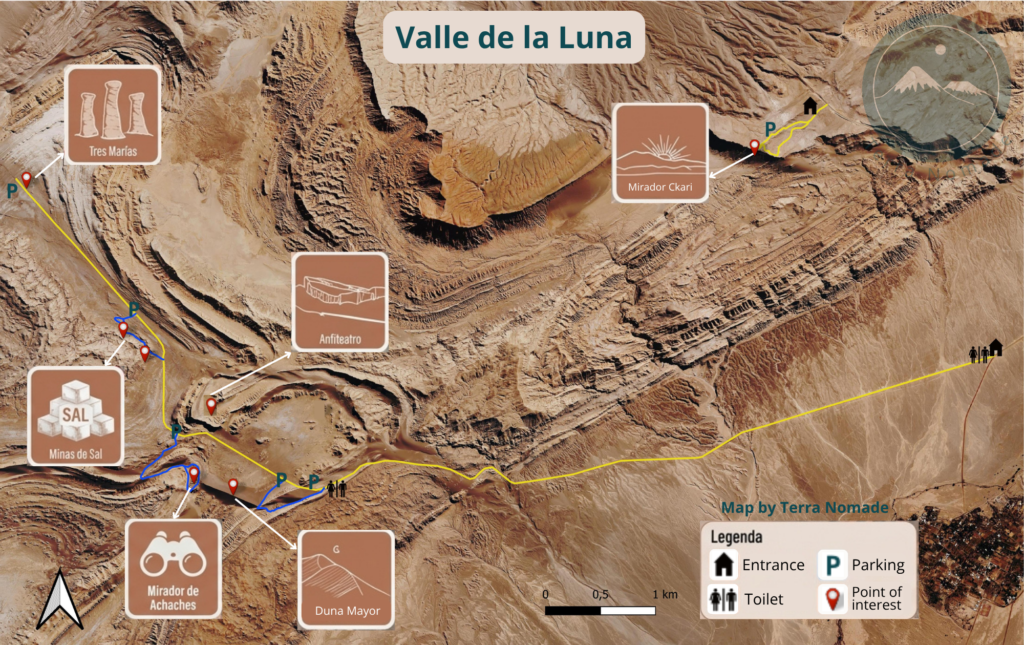
The map shows the entrance to the Valle de la Luna park.
Formation and transformation of the landscape
The Valle de la Luna lies within the Cordillera de la Sal, a mountain range made up mainly of sedimentary rocks and evaporite deposits rich in salt. Its history is closely linked to that of the Salar de Atacama basin: more than 20 million years ago, sediments accumulated in the ancient basin were progressively deformed, compressed and uplifted by tectonic activity, giving rise to the mountain range that now forms the western edge of the Salar de Atacama.
The sediments that have accumulated and continue to accumulate in the lowest part of the Salar basin come mainly from the nearby Cordillera de los Andes and Cordillera de Domeyko. The evaporite deposits, on the other hand, are mainly the result of the evaporation of water that feeds the Salar: minerals dissolved from the surrounding volcanic rocks are carried in solution and later precipitate and accumulate in the basin due to intense evaporation.
The main types of rocks and minerals that can be observed in the Valle de la Luna are therefore sandstone, siltstone, mudstone and conglomerate, with layers and accumulations of gypsum, halite (rock salt), anhydrite and other evaporite minerals.
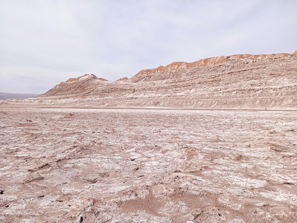
Once exposed at the surface, these rocks began to be shaped and altered by the elements. In an extremely arid environment like the Atacama, water is only present episodically, but it can have a very strong erosive effect during rainfall events. The wind, on the other hand, continuously removes and transports finer particles, while the large temperature variations between day and night contribute to physical weathering, breaking down the rocks through repeated cycles of expansion and contraction.
The different composition of the rocks has also played a fundamental role. Materials that are more easily altered and eroded are progressively removed, while more resistant ones remain standing out in the landscape: this is known as differential erosion, and it is responsible for many of the caves and distinctive formations found throughout the Cordillera de la Sal and Valle de la Luna.
In addition, the oxidation of iron-bearing minerals contributes to the reddish tones found in many parts of the Cordillera de la Sal, adding further variations in color to a landscape dominated by whites, greys, beige and ochre.
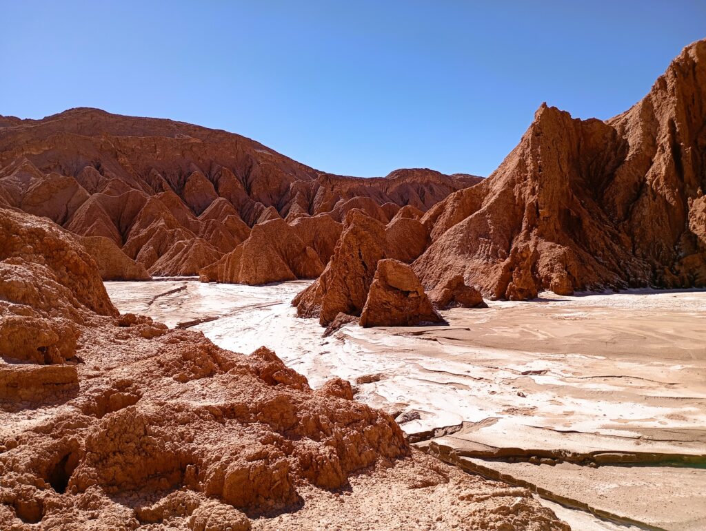
The landscape we see today is therefore the result of a history that began millions of years ago and is still evolving.
→ If you want to learn more about the geological context and the formation of the Atacama Desert and Salar de Atacama, read the dedicated article.
What to see
The Valle de la Luna features several points of interest, each with different geomorphological and geological characteristics. The map below shows the main stops along the route, which we’ll look at in detail one by one.
Gran Duna or Duna Mayor
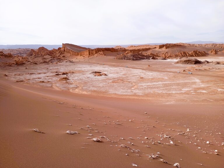
The Duna Mayor is located opposite the area originally known as the Cráter Central or Valle de la Luna, a large depression that is clearly visible when viewed from above.
Dunes are landforms created by the accumulation of sediments transported by the wind. For a dune to form, there must therefore be available sediments and wind action capable of transporting and depositing them.
In the case of the Duna Mayor, the sediments mainly come from the weathering of the Cordillera de Domeyko, which is why the sand has a dark color, while the accumulation of sediments in this area has been favored by the morphology of the Cordillera de la Sal itself, which has hindered their transport by wind.
One fascinating feature of dunes is that by looking at their profile, you can infer the direction of the wind. Dunes have an asymmetrical profile: the windward side generally has a gentler slope, along which sand moves upward; once it reaches the crest, the grains fall down the opposite side (the leeward side), which is steeper. In the case of the Duna Mayor, however, its profile does not allow us to immediately determine the prevailing wind direction, as the dune is relatively symmetrical and influenced by multidirectional wind patterns. By combining this observation with the basin’s morphology, however, a prevailing wind component from right to left in the photo can be identified: the basin opens towards the northeast, favoring the transport of sediments towards the southwest, where they encounter the barrier formed by the Cordillera de la Sal.
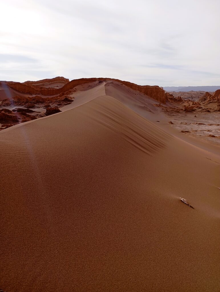
Today, walking along the ridge or climbing the dune is no longer permitted in order to protect its fragile structure, but you can reach two viewpoints on foot via a well-marked trail across the solid rock in front of it. The full trail is about 1 km long and takes around 25 minutes, including stops.
Mirador Achaches
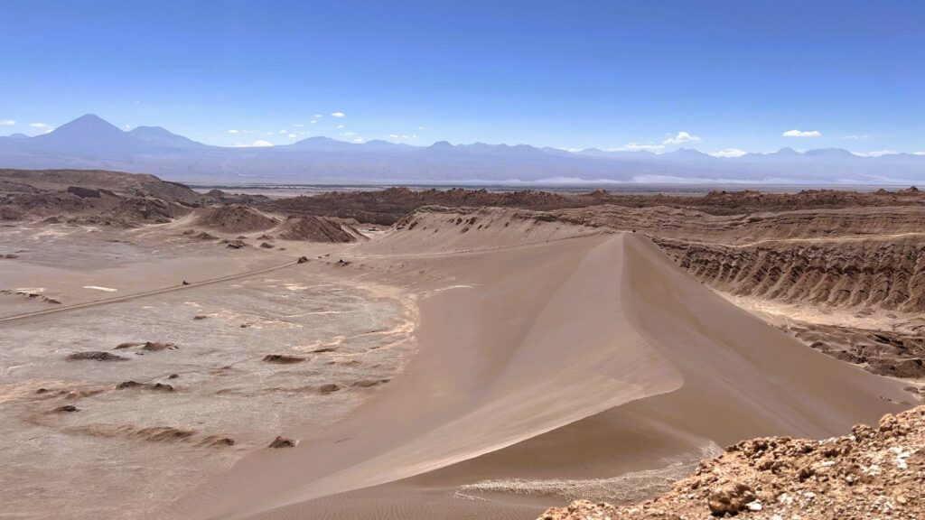
The Mirador Achaches is located on the opposite side from the Duna Mayor and can be reached via a trail that starts shortly after it. The trail climbs along a ridge of the Cordillera de la Sal, offering a different perspective on the formations that characterize the Valle de la Luna.
From the top, you can enjoy wide views over the valley, dunes and geological formations, while in the distance the volcanic range of the Andes comes into view. From here, you can also see the area known as Cornisas, characterized by ridges and folds formed by the rocks of the so-called San Pedro Formation, the oldest geological formation in the Cordillera de la Sal. Formed during the Oligocene (between 34 and 23 million years ago), it consists mainly of sedimentary rocks, including sandstone and mudstone, associated with evaporite deposits, and features prominent folds caused by tectonic deformation.
The trail is more challenging than the one to Duna Mayor, with an uphill section over rocky and sandy terrain. The full route is about 3 km and takes just over 1 hour of walking, depending on your pace and how often you stop.
Anfiteatro
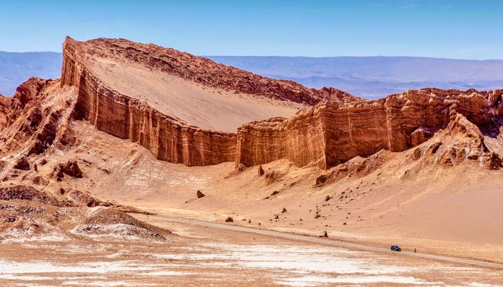
The Anfiteatro is one of the most distinctive formations in the Valle de la Luna. It is an imposing rock wall reaching around 40 meters in height. Its curved, layered structure resembles that of a Roman amphitheatre, which is where its name comes from.
From a geological perspective, the Anfiteatro belongs to the Vilama Formation, which formed more than 9 million years ago and consists mainly of fine-grained clastic rocks. Unlike the San Pedro Formation, it also contains ash from volcanic activity in the Andes and features generally more horizontal, less deformed layers.
It is not possible to climb this rock formation, but it can be viewed from the main trail through the Valle de la Luna.
Mina Victoria
In the Valle de la Luna, salt extraction gave rise to several small mines, which were particularly active from the 1960s onwards and were owned by different families from San Pedro de Atacama. Among them was the Mina Victoria, owned by don Gabino Aguilar, who named it after his wife, Victoria Vilca.
Extraction was carried out by digging tunnels into the rock, and the mine consisted of several underground passages. Today, the tunnels are not accessible to visitors, but a trail of about 1 km allows you to see some of the former mining areas and the remains of the old mining structures, a reminder of this more recent chapter in the history of this part of the Cordillera, formerly known as Las Salinas.
The excavated section is particularly interesting from a geological perspective as well: if you stop and listen, you can hear the characteristic crackling of the rocks, caused by thermal weathering, the breakdown of rock resulting from the strong temperature variations between day and night.
Las Tres Marías
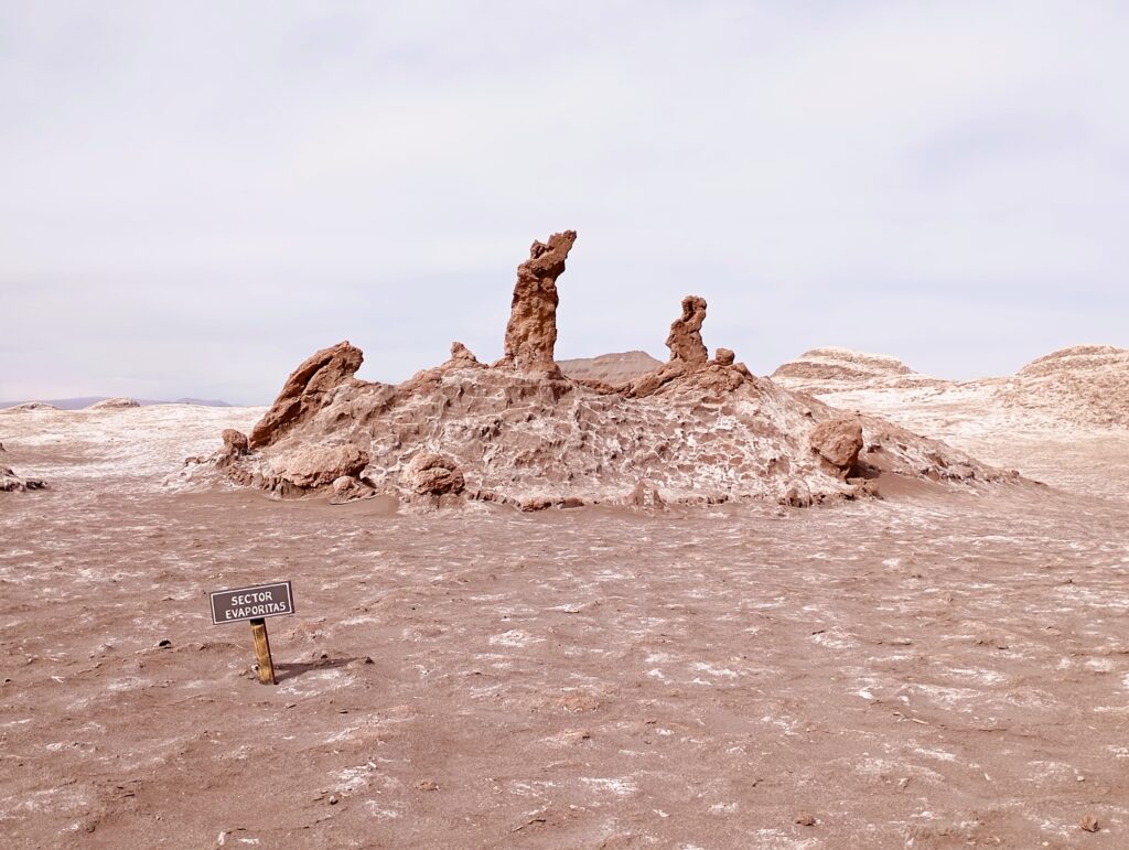
Las Tres Marías are three distinctive rock formations, named for their resemblance to the silhouette of three women kneeling in prayer. These rocks are an example of differential erosion: more easily soluble minerals, such as halite and gypsum, have been progressively dissolved and removed by water, while more resistant materials have remained standing out, giving rise to the shapes we see today.
In 2006, one of the three formations was partially destroyed, so only two remain visible today. The area was originally known by the people of San Pedro de Atacama as Los Vigilantes and was used by Atacameño communities for pagos a la tierra, traditional ceremonies offering gifts to the earth.
Mirador de Ckari
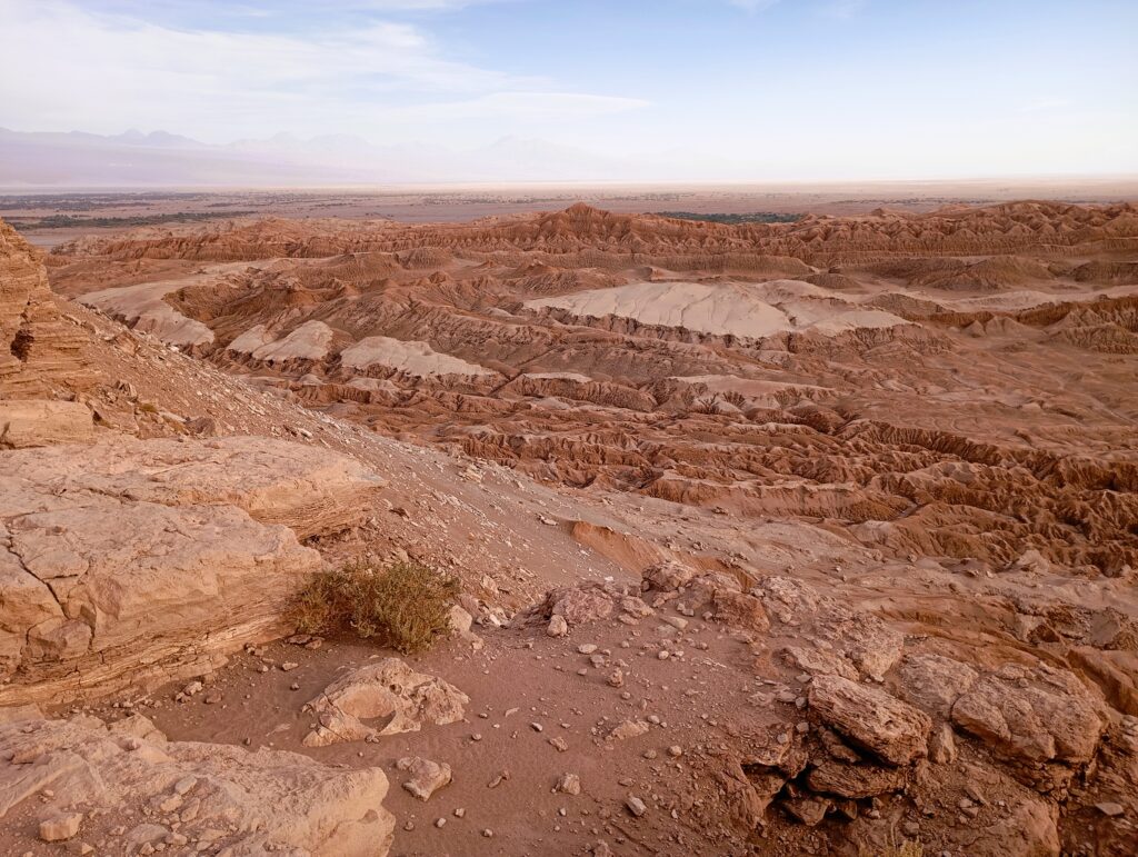
The Mirador de Ckari offers one of the widest views over the Valle de la Luna and the Salar de Atacama basin. From here, you can see the Cordillera de la Sal and, beyond the basin, the other mountain ranges that surround it, including the Cordillera de Domeyko to the west, the Cordón de Lila to the south, and the Andes to the east.
The name Ckari comes from the quebrada at the foot of the viewpoint, which gives the area its name. The area is also known today as Piedra del Coyote, a name inspired by the distinctive shape of the rock on which the viewpoint is located.
How to visit Valle de la Luna
The Valle de la Luna can be visited independently, by bicycle or car, or as part of an organized tour with a tour operator. It is not possible to visit it on foot.
By bicycle
Visiting Valle de la Luna by bicycle requires time and energy. From the center of San Pedro de Atacama to the park entrance, it is about 12 km, while the main route inside the park is around 18 km in total, including the return journey.
The main challenge is that the route runs entirely along unpaved, sandy roads, with some more demanding sections, such as the climb before Duna Mayor, where you may need to get off your bike and continue on foot. You also need to take into account the intense sun, heat and very dry air, which make the physical effort more demanding. To reach Mirador de Ckari, you also have to ride along a section of road shared with cars, mostly uphill.
Visiting by bicycle is therefore best suited to those who are already reasonably fit, so that fatigue does not end up taking away from the experience.
Entry by bicycle is also only permitted during the early hours of the day, from the park’s opening time, which varies depending on the season, until 11:00 am. This time limit is related to the length of the visit: it takes around 5–7 hours to explore the entire park with stops, and the last entry to some attractions is around 4:00 pm. It is therefore advisable to enter as early as possible.
By car
A car allows you to visit the park with greater flexibility and stop at the different points of interest at your own pace. Allow around 4 hours to complete the full route and visit the main attractions, depending on how long you spend at each stop.
With a tour operator
Shared group tours generally take place in the afternoon and last around 4 hours. The itinerary includes the main points of interest in Valle de la Luna, followed by a stop at Mirador de Ckari to watch the sunset, with a cocktail before returning to San Pedro. Mirador Achaches, on the other hand, is normally not included in shared tours, as the trail to reach it takes too long compared to the overall duration of the visit.
Entrance
Entrance to the park is subject to a fee, and tickets can be purchased online or directly at the entrance, where a card payment terminal is available. Cash is not accepted. Prices are the same for all visitors, regardless of nationality. Children under 11 enter free of charge, while visitors aged 11 to 17 and those over 60 pay a reduced fee of CLP 5,400. For visitors between 18 and 60, the ticket costs CLP 10,800.
Opening hours and access conditions may vary depending on the season or specific circumstances. Before visiting, it is therefore advisable to check the official Valle de la Luna website, where you can find up-to-date information on opening hours, prices and access conditions.
The Mirador de Ckari has a separate entrance from the main Valle de la Luna route. However, you must first enter through the park’s main entrance before continuing to the viewpoint.
Note: The Mirador de Ckari is currently closed to the public due to damage caused by an earthquake. It is expected to reopen, but it is advisable to check access conditions before visiting.
When to go and how to prepare
Valle de la Luna can be visited year-round. In summer, especially between December and February, temperatures can be very high, making walks particularly strenuous, especially on uphill sections. In winter, daytime temperatures are generally milder.
Throughout the year, it is important to keep weather conditions in mind: rain, strong winds and intense lightning activity may lead to the park being closed. Rain and lightning are more likely during summer, while strong winds tend to be more common in winter. Before visiting, it is therefore always advisable to check the weather forecast and the park’s official website for any updates on access.
In any season, it is important to protect yourself from the sun with a hat, sunglasses and sunscreen, as there are no shaded areas in the park. It is also advisable to wear comfortable, closed-toe shoes suitable for walking: the sand can become very hot, so even in summer it is best to avoid sandals. Finally, make sure you bring enough water, as there are no places inside the park where you can buy drinks. Given the strong temperature variations typical of the desert, it is also advisable to bring a sweater or sweatshirt, especially if you visit the park in the afternoon to watch the sunset.
My tips
Although it is at the same altitude as San Pedro de Atacama and therefore does not present any particular challenges related to altitude, Valle de la Luna is not an excursion to underestimate. The heat and sun can be very intense, especially in summer. There are no shaded areas along the route, and even when the air temperature does not seem particularly high, direct sunlight and dry air can make the visit more strenuous than expected. It is therefore important to be prepared and take the conditions on the day into account.
For this reason, personally, I wouldn’t choose to visit Valle de la Luna by bicycle. With the distance, sandy terrain and uphill sections, you may end up more tired than satisfied by the end of the visit. If you want to explore the area around San Pedro by bicycle, I would instead choose Valle de la Muerte, which is closer and smaller to explore.
For visiting Valle de la Luna, I would therefore choose a car or an organized tour. If you prefer to visit independently and want to avoid the crowds, it is better to go in the morning, when most tour operators have not arrived yet. Personally, though, I would choose the afternoon, as the late-afternoon light brings out the landscape beautifully and allows you to finish your visit with the sunset.