Table of contents
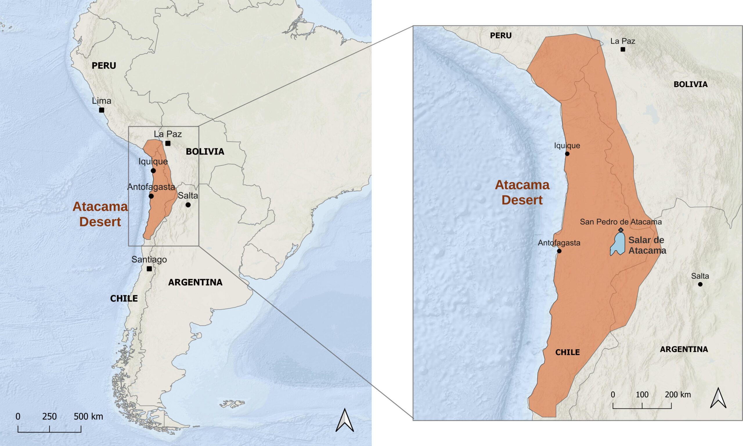
Where are the Atacama Desert and Salar de Atacama located?
Certo, mantengo i tag HTML come nell’originale. Correggo solo la formattazione del grassetto:
The Atacama Desert is located in northern Chile and covers an area of approximately 105.000 km², an extension comparable to that of Iceland. The desert area stretches between the Pacific Ocean and the Cordillera de los Andes for more than 1.600 kilometres from north to south, crossing the regions of Arica and Parinacota, Tarapacá, Antofagasta, and Atacama.
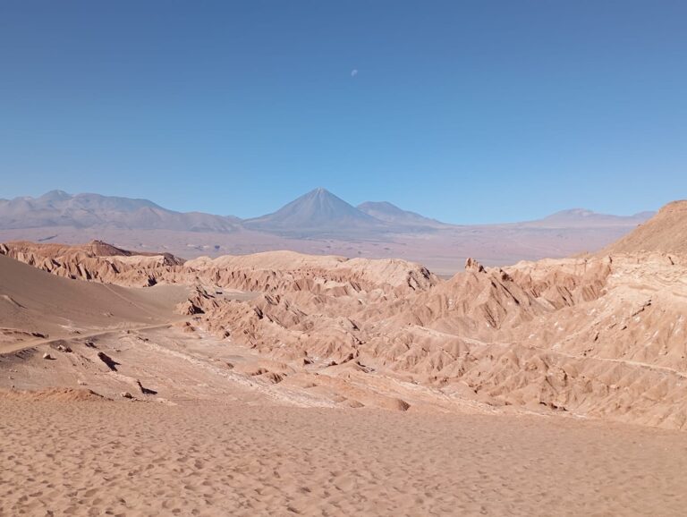
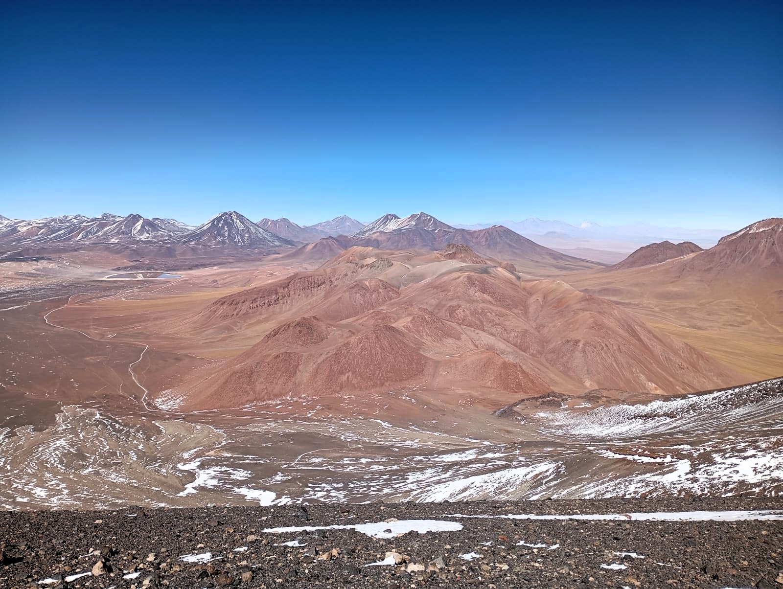
Considered the driest non-polar desert on Earth, the Atacama is not simply a vast expanse of sand, but a large area characterized by extremely diverse landscapes. Salt flats, rocky valleys, canyons, high-altitude lagoons, and geysers alternate throughout the desert, while along its eastern margin, where the desert meets the Cordillera de los Andes, some of the highest volcanoes in the world can be found.
Within this vast desert area there are numerous salt flats, including the Salar de Atacama, a large salt depression located in the Antofagasta Region at the foot of the Andes. With a surface area of approximately 3.000 km², it is the largest salt flat in Chile and the third largest in South America, after the Salar de Uyuni in Bolivia and the Salinas Grandes in Argentina.
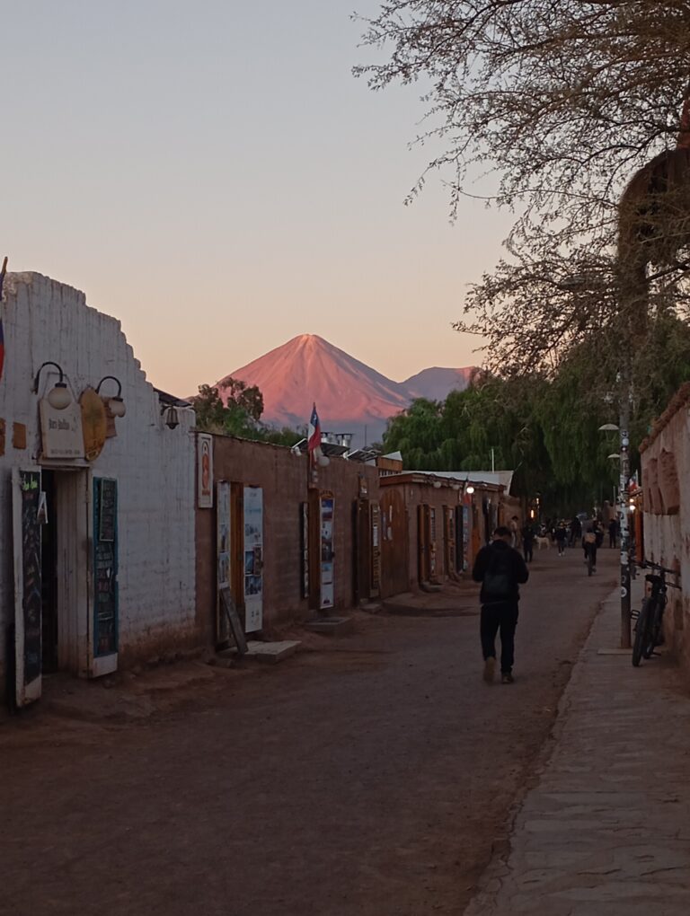
Such a vast territory can be explored from several locations in northern Chile. Among them, San Pedro de Atacama is one of the main starting points for visiting the Salar de Atacama and some of the most representative landscapes of the surrounding area.
The structure of the Atacama landscape
The Atacama Desert is not a uniform environment, but a territory made up of different landscape units, defined in geology as physiographic units, which extend parallel to the coastline in a north-south direction. Moving from the ocean inland, these include: the Cordillera de la Costa, a mountain range that separates the coast from the interior; the Depresión Central, which contains much of the desert surface; the Cordillera de Domeyko; other internal depressions; and finally the Cordillera de los Andes, which hosts the highest elevations and active volcanoes of the region. In this sector, the Andes are divided into two branches: the Western Cordillera, where much of the volcanic activity is concentrated, and the Eastern Cordillera, mainly composed of mountain ranges. Between the two lies the Altiplano, a vast high plateau located at over 3.500 metres above sea level.
Note
What is the Altiplano?
The Altiplano (with a capital A) is the name of the large intermontane plateau of the Central Andes, located between the Western and Eastern Cordilleras. It is therefore a geographical name that identifies a specific area, just as Salar de Atacama identifies a specific salt flat.
A plateau, on the other hand, is generally a broad, relatively flat surface located at a higher elevation than the surrounding areas. In Spanish, the generic term is altiplano, the same word also used as the proper name of the Andean region.
For this reason, especially in the tourism sector, the term altiplano is often used more broadly to refer to the high-altitude areas located between the Cordillera de los Andes and the Cordillera de Domeyko.
Within this general structure, some areas show particular characteristics. In the area where San Pedro de Atacama is located, for example, between the Cordillera de Domeyko and the Cordillera de los Andes, the Cordillera de la Sal develops as an additional mountain range running parallel to the coast. Together with the Cordillera de los Andes, it defines the boundaries of a vast basin, within which the Salar de Atacama extends. The arrangement of these major landscape units is not random, but rather the result of a long geological history that began millions of years ago.

How did this structure form?
The landscape of the Atacama Desert is the result of a geological process that began over 200 million years ago and is still active today. Over this long period, tectonics, volcanism, and climate have acted together, progressively shaping the landscape we see today.
Tectonics and volcanism
At the foundation of the formation of the Atacama Desert lies the movement of tectonic plates and, in particular, a process known as subduction.
Tectonic plates are large portions of the lithosphere, which consists of the Earth’s crust and the uppermost part of the mantle, that continuously move at rates of a few centimetres per year. During this movement, plates can move apart (diverge), move towards each other (converge), or slide past one another. When two plates converge, they begin to collide. If one of the two is made up of oceanic crust, which is denser and heavier than continental crust, it tends to sink beneath the latter, slowly descending into the Earth’s mantle. This process is known as subduction. Along the western coast of South America, the Nazca Plate, made up of oceanic crust, is still subducting beneath the South American Plate, which is made up of continental crust. It is precisely this movement, active for millions of years, that has shaped the landscape we see today.

The subduction process produces two fundamental effects. On one hand, the compression of the continental crust causes its progressive folding and thickening. On the other hand, the subducting oceanic plate reaches increasingly higher temperatures and pressures, promoting the formation of magma that rises towards the surface and feeds continental volcanism. This is how volcanic arcs develop along subduction zones, consisting of chains of volcanoes that form parallel to the continental margin.
Subduction is also a dynamic process. Over millions of years, numerous factors can cause the volcanic arc to slowly migrate towards the interior of the continent. In the Atacama region, this process has meant that the main mountain ranges did not form at the same time, but instead represent different stages in the geological evolution of the region.

Simplified model of the subduction of the Nazca Plate beneath the South American Plate. During subduction, the oceanic plate releases water into the overlying mantle materials, lowering their melting point and promoting magma formation. This process generally occurs at depths of approximately 100 to 150 km and feeds the volcanic arc. 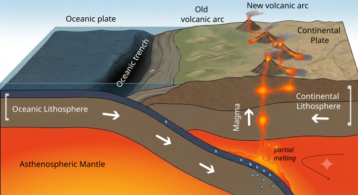
Simplified model of the migration of a volcanic arc. This migration can be caused by several factors related to the evolution of the subduction system; this figure illustrates the case of a change in the angle of the subducting oceanic plate. Since mantle melting tends to occur within a relatively constant depth range (approximately 100–150 km), a plate subducting at a lower angle reaches these depths farther from the coast, causing the volcanic arc to shift towards the interior of the continent.
The Cordillera de la Costa, which is the closest to the subduction margin, represents the remnants of the oldest magmatic arc of this system, which developed between approximately 200 and 120 million years ago (Jurassic–Early Cretaceous). Subsequently, the progressive migration of magmatic activity towards the interior of the continent, together with tectonic deformation, led to the development of the Cordillera de Domeyko, which formed mainly between approximately 80 and 30 million years ago (Late Cretaceous–Oligocene). The Cordillera de los Andes, which hosts the current volcanic arc, is instead the youngest: its development continued mainly during the last 30 million years (Neogene) and is still ongoing today, as shown by the presence of numerous active volcanoes along the border between Chile and Argentina.
The role of climate
While subduction continued to shape the western margin of South America and volcanic arcs progressively migrated eastward, numerous internal depressions began to develop between the mountain ranges. These lower areas became depositional basins, where sediments eroded from the surrounding highlands, volcanic materials, and minerals transported by water accumulated over millions of years, forming thick sedimentary deposits.
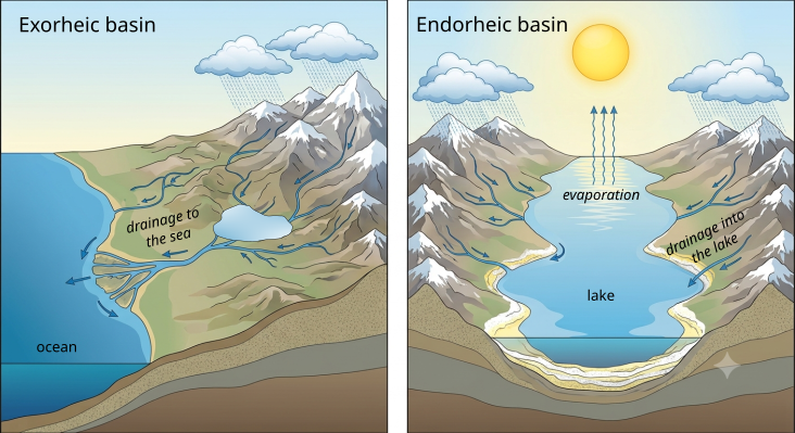
With the progressive uplift of the mountain ranges, some of these basins became isolated from the sea and turned into endorheic basins, meaning closed basins where water can enter but cannot find an outlet to the ocean. In the past, the climate of the region was also less arid than it is today, with more abundant precipitation. Water from rainfall and snowmelt therefore began to accumulate within these depressions, gradually forming a vast system of lakes.
With the progressive aridification of the climate, evaporation began to exceed water input. The lakes gradually dried up, while dissolved minerals started to crystallize and accumulate on the bottom, forming thick layers of salts and other evaporite deposits. This is how salar form: vast salt flats that occupy the lowest points of endorheic basins.
Meanwhile, in some of these basins, compression generated by tectonic activity deformed the salt-rich sedimentary deposits, folding and uplifting them. This is what occurred in the Salar de Atacama basin, where this process gave rise to the Cordillera de la Sal, a sedimentary mountain range that is very different from the nearby Cordillera de Domeyko and Cordillera de los Andes, which are instead associated with intense volcanic and magmatic activity.
Within this basin, the ancient deformed layers form the Cordillera de la Sal, while the lowest point is occupied by the salar, where waters from the Andes continue to accumulate. Since the basin is still endorheic today and the climate remains extremely arid, the water flowing into it evaporates without reaching the sea, promoting the continuous accumulation of salts and minerals.
The Salar de Atacama is not an isolated case: throughout the Atacama Desert, there are numerous other salt flats and similar saline environments, such as the Salar de Pedernales, formed by the same processes of evaporation and salt concentration.
From geology to the main environments
The geological processes described in the previous chapter have shaped the structure of the Atacama Desert and given rise to the environments that characterize it today. Lagoons, geysers, and volcanoes, like many other desert environments, are not isolated features of the landscape, but rather the result of processes that continue to slowly transform the territory even today.
Lagoons and wetlands
Despite its extreme aridity, the Atacama Desert hosts numerous water bodies, including lagoons and wetlands. The presence and characteristics of these environments mainly depend on the balance between the water entering the internal basins and the water lost through evaporation. When water input is very limited and evaporation prevails, the basin tends to transform into a salar. Where water input remains sufficient, permanent or seasonal lagoons can be preserved, often characterized by high levels of salinity.
Where does the water come from if it does not rain?
Although local precipitation is extremely scarce, the water that feeds these water bodies mainly comes from precipitation and snowmelt in the Andes. This water reaches the basins through rivers and groundwater systems, which are fed by precipitation that can occur even tens of kilometres away.
Given the high evaporation rates, however, the amount of water that reaches these basins is generally insufficient to form large permanent lakes. Instead, lagoons develop: generally shallow water bodies whose balance depends on a continuous water supply. If this input remains constant, the lagoon can persist over time. If, on the other hand, evaporation prevails, salts gradually become concentrated until they form extensive salt crusts. This delicate balance explains why, even at short distances from one another, lagoons can have very different sizes, salinity levels, colours, and biological communities.
Why are some lagoons so salty?
The water feeding these lagoons flows through volcanic and sedimentary rocks rich in highly soluble minerals, which are progressively dissolved and transported into the internal basins. This is why these waters are naturally rich in dissolved chemical elements.
However, not all waters follow the same pathways or pass through the same types of rocks. For this reason, some lagoons have relatively low-salinity waters, while others reach very high salt concentrations. For example, Laguna Cejar and the Baltinache lagoons reach a salinity of around 23%, corresponding to a salt concentration approximately six times higher than that of seawater.
Geysers and hot springs
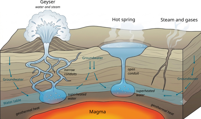
Geysers and hot springs are among the most visible expressions of the intense geothermal activity still present beneath the Cordillera de los Andes. Although magma remains confined several kilometres below the surface, the heat it releases is sufficient to warm groundwater.
How do geysers form?
These phenomena are relatively rare on Earth because they require the simultaneous presence of three conditions: a heat source, abundant groundwater, and a particular system of cavities and conduits capable of accumulating pressure.
In the Atacama Desert, part of the water originating from the Andes infiltrates the ground and reaches great depths, where it is heated by the heat released from magma chambers. The portion of water closest to the heat source begins to “boil” and, because the underground conduits are narrow and sealed, pressure within the system progressively increases. When the pressure exceeds a certain threshold, the entire column of water above and the steam are violently expelled towards the surface. This mechanism generates the characteristic jets of boiling water, which can reach several metres in height, and distinguishes a geyser from a simple fumarole, where mainly gases and steam are released. Once the conduit has emptied, it fills again and the cycle begins anew.
If, on the other hand, the underground conduit were wider and open, pressure could not build up, and the hot water would simply rise to the surface, creating a hot spring, such as those found at Río Puritama.
The best-known example of this phenomenon in the Atacama Desert is represented by the El Tatio Geysers. Located at an altitude of approximately 4.300 metres, they are the largest geothermal field in the Southern Hemisphere and one of the highest in the world, with more than 80 active geothermal features.
→ If you want to learn more about the characteristics of the El Tatio Geysers, I have dedicated a specific article to this extraordinary geothermal field in the Atacama.
Volcanoes
Another clear evidence of the volcanic and geothermal activity still present beneath the Cordillera de los Andes is certainly provided by the numerous volcanic edifices of the range.
Many of these volcanoes are stratovolcanoes, meaning they have the characteristic cone shape formed by the accumulation of lava flows and pyroclastic materials over time. Several can be observed around San Pedro de Atacama, including the famous Licancabur and Lascar, which reach elevations above 5.000 metres. The magma that feeds this volcanism is relatively rich in silica (mainly andesitic and dacitic), and therefore sufficiently viscous to favour, under certain conditions, explosive eruptions.
Not all of these volcanoes are equally active: some are considered active but currently dormant, while others still show signs of activity, such as fumaroles and hot springs. The Lascar, for example, is the most active volcano in northern Chile and has produced several eruptions in recent decades. However, the level of risk varies considerably from one volcano to another and does not mean that the entire region is constantly exposed to danger.
The numerous eruptions that have occurred throughout geological history have also contributed to shaping the landscape we see today, leaving behind lava flows and large pyroclastic deposits, including tuffs and ignimbrites. Many of the landforms and rocks encountered during excursions in the region are therefore the direct result of this long volcanic activity. A particularly striking and well-known example is the ignimbrites of Piedras Rojas, whose characteristic red colour is related to the oxidation of iron contained in the minerals.
→ If you want to learn more about volcanic products and understand how the different rocks that characterize the Atacama landscape formed, you can find here a dedicated article on volcanoes and igneous rocks, with some examples that can be directly observed in the region.
The role of erosion and weathering
In addition to volcanism and tectonic processes, surface processes have also played a fundamental role in shaping the landscape of the Atacama. Weathering includes all processes that alter and break down rocks directly in place, while erosion also involves the removal and transport of material by water, wind, ice, and gravity.
In an arid environment like the Atacama, the strong temperature variations between day and night mainly favour physical weathering: repeated heating and cooling cycles cause rocks to expand and contract, which over time can promote fracturing and breakdown. This process can be perceived while walking through the Cordillera de la Sal, where rocks may produce small cracking sounds during temperature changes.
Chemical weathering also alters rocks by acting on the minerals they contain and progressively modifying their composition and some of their characteristics, such as colour. In a volcanic environment like the Atacama, rich in rocks containing silicate minerals, their chemical alteration can lead to the formation of clay minerals, which are subsequently transported and accumulated in the region’s sedimentary basins. This process gives rise to deposits rich in clay minerals, which have been used for centuries by local populations in the production of traditional ceramics.
Erosion, on the other hand, has contributed to sculpting and transporting the previously weathered material, creating some of the most characteristic landforms of the region. In the Cordillera de la Sal, the action of water and wind has produced canyons, badlands, caves, and dunes, while in the region’s large volcanic formations, differential erosion has progressively removed the more easily eroded material, leaving the more resistant rock portions standing out, as seen in the Monjes de la Pacana, enormous isolated rock blocks.
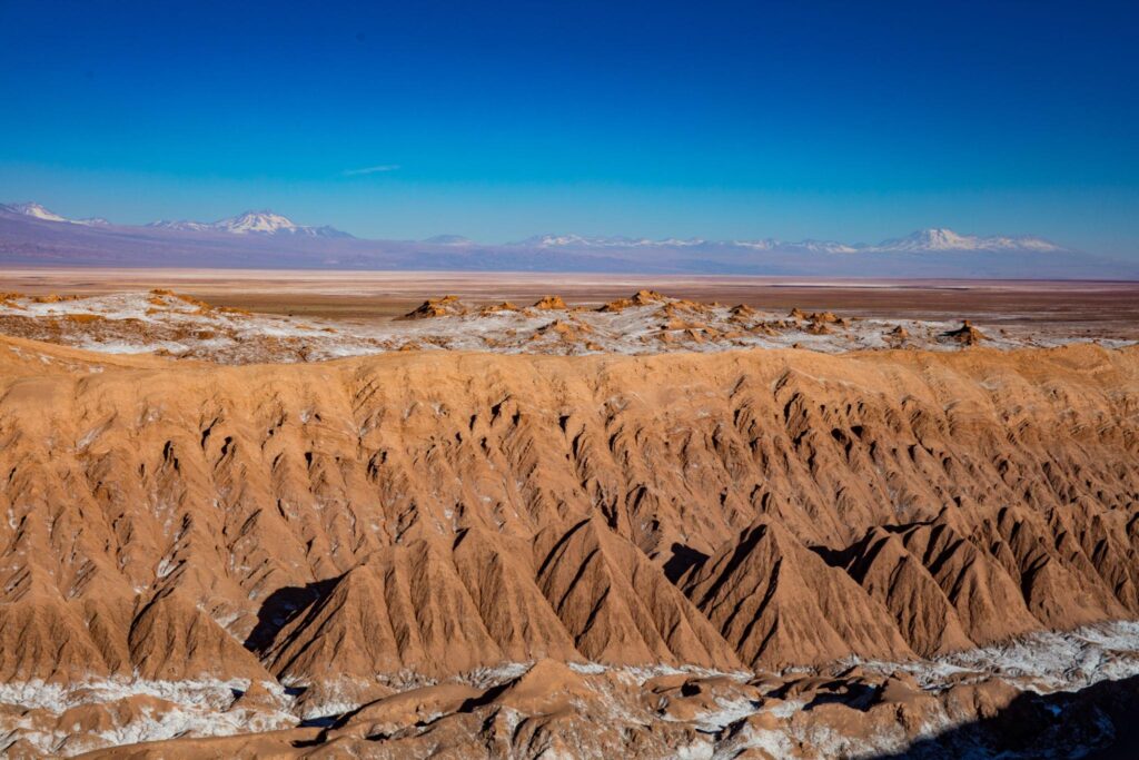
The badlands of the Cordillera de la Sal are erosional landforms created by the action of water on easily erodible materials, which were subsequently further shaped by wind in an extremely arid environment. 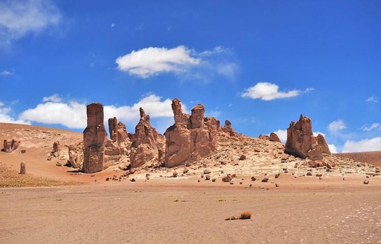
The Monjes de la Pacana are large isolated blocks of ignimbrite shaped by differential erosion, which has progressively removed the less resistant material, leaving the more compact portions of the rock exposed.
These processes have not only shaped already exposed rocks, but have also contributed to the exhumation of rocks that were originally located at great depths, bringing them to the surface. This is the case of the Cordillera de Domeyko, where erosion, combined with the uplift of the mountain range, has progressively removed the overlying rocks, allowing numerous plutonic rocks to be observed at the surface today. These are igneous rocks that formed within the Earth’s crust millions of years ago.
→ Want to discover which of these environments you can visit starting from San Pedro de Atacama? In thededicated article you can find all the main excursions around San Pedro, organized by environment and landscape features.
Why is the Atacama the driest desert in the world?
The extreme aridity of the Atacama Desert results from the combination of several atmospheric and geographical processes that strongly limit precipitation. The three main factors are: 1) the Humboldt Current, 2) the presence of mountain ranges, and 3) the effect of the permanent subtropical high-pressure system of the South Pacific.
1) The Humboldt Current is a cold ocean current that originates from Antarctica and flows northward along the western coast of South America. By cooling the air in contact with the ocean, it reduces evaporation and makes the formation of rain-bearing clouds more difficult.
In addition to this, another process contributes to cooling the surface waters: upwelling. This phenomenon occurs when the trade winds, which blow from east to west, push surface waters along the coast towards the centre of the Pacific Ocean. This movement favours the upward movement of cold, nutrient-rich deep waters. The phenomenon therefore contributes to further cooling of the overlying air and makes the Peruvian and Chilean coasts among the most productive marine areas in the world.
2) The presence of mountain ranges creates a physical barrier to humid air masses. The Cordillera de los Andes, for example, acts as a barrier for air masses coming from the Amazon basin, which release much of their precipitation on the eastern side of the mountain range. By the time they reach the western side, where the Atacama Desert is located, they are already much drier. This phenomenon is known as a rain shadow. The Cordillera de la Costa also contributes to the aridity of the interior, although to a lesser extent. The limited moisture that forms above the ocean remains largely confined to the coastal zone, where it gives rise to a dense fog known as camanchaca. This fog supports particular ecosystems known as lomas, but only rarely produces significant precipitation.
3) Finally, much of the Atacama is influenced by the permanent subtropical high-pressure system of the South Pacific, an area of high pressure characterized by descending air. As the air sinks, it becomes compressed, warms up, and progressively dries out, further hindering the formation of clouds and precipitation. In addition, the warm air at higher altitudes acts as a sort of “lid”, preventing the colder air near the surface from rising. This creates a temperature inversion that limits convective motions (strong vertical air movements) and keeps the atmosphere particularly stable.
The combination of these factors makes the Atacama one of the driest environments on Earth. Along the coast, cities such as Antofagasta and Iquique receive on average only a few millimetres of rainfall per year (approximately 1-3 mm). In some inland areas, years or even decades can pass without measurable precipitation. For comparison, cities such as Milan or Rome receive an average of between 700 and 1.000 mm of precipitation per year.
This balance, however, can be temporarily disrupted by the climate phenomenon known as El Niño. During this phase of the ENSO climate cycle (El Niño-Southern Oscillation), the surface waters of the central and eastern Pacific warm up abnormally. Warmer ocean temperatures favour increased evaporation and make the formation of clouds and precipitation along the western coast of South America more likely. During these periods, exceptional rainfall events can therefore occur in the Atacama Desert, responsible, among other effects, for the famous flowering desert phenomenon. The ENSO cycle also includes an opposite phase, known as La Niña, characterized by colder-than-average surface waters and, generally, even drier conditions. El Niño and La Niña events alternate irregularly, with intervals of approximately 2-7 years and a duration that can range from a few months to more than a year.
In addition to El Niño, the so-called Altiplano winter can also bring precipitation to the desert. This is a seasonal phenomenon that mainly affects the austral summer months. During this period, humid air masses from the Amazon basin can, under particular atmospheric conditions, cross the Cordillera de los Andes, generating storms mainly in high-altitude areas and around San Pedro de Atacama.

Why is the Atacama a unique place in the world?
The Atacama is a place where exceptional geological, climatic, and environmental conditions combine to create one of the most extraordinary natural laboratories on Earth.
Within a single area, it is possible to observe a wide range of geological and geomorphological processes that have developed over millions of years, study extreme environments where life has adapted to harsh conditions, observe the universe using some of the most advanced astronomical instruments in the world, and test technologies designed for the exploration of other planets.
An open-air geological laboratory
As we have seen in this article, the landscape of the Atacama is the result of the interaction between geological and climatic processes that have shaped the region over millions of years. The result is an extremely diverse environment, where it is possible to observe evaporite deposits, salt lagoons, salt flats, volcanoes, geysers, canyons, and rock formations shaped by erosion.
This extraordinary concentration of phenomena makes the Atacama a true natural laboratory for understanding the processes that have shaped the Earth’s surface.
Life at the limits of extremes
The extreme conditions of the Atacama have given rise to highly specialized ecosystems, where microorganisms, plants, and animals have developed unique strategies to survive in one of the most challenging environments on the planet.
The scarcity of water, high solar radiation, strong temperature variations, and the presence of environments rich in mineral salts have favoured the evolution of highly specialized biological adaptations, making the Atacama a place of great interest for studying the limits of life on Earth.
One of the best places in the world to observe the sky
The same conditions that make the Atacama one of the driest environments on the planet also make it one of the best places in the world for astronomy.
The almost complete absence of precipitation, extremely low atmospheric humidity, high altitude, and limited light pollution create ideal conditions for observing the cosmos.
For this reason, the desert hosts some of the world’s most important ground-based astronomical observatories, including ALMA, located on the Chajnantor Plateau at an altitude of approximately 5.000 metres.
A Mars-like environment on Earth
The combination of characteristics of the Atacama (extreme aridity, mineral-rich soils, high ultraviolet radiation, and unique environmental conditions) also makes it one of the terrestrial environments most similar to the surface of Mars.
For this reason, the desert is used as a research and testing site for instruments designed for planetary exploration. Studying this environment also helps us better understand the limits of life on Earth and the conditions that could make the presence of life forms on other planets possible.
Ultimately, the uniqueness of the Atacama lies precisely in the combination of seemingly opposite elements: it is an extremely arid environment yet rich in biodiversity, an ancient landscape that is fundamental to future research, a place on Earth that allows us to study both the history of our planet and the possibilities of exploring other worlds.
This awareness is precisely what makes a journey through the Atacama even more special: after understanding its origin and formation, its beauty no longer lies only in its landscapes, but also in the natural processes that shaped them and the stories they hold.